Trekking tra i borghi del territorio di Faltona
Natura, storia, ampi panorami, corsi d’acqua stupenti e il percorso per Santa Trinita
Italiano
IN VISITA AL TERRITORIO DI FALTONA – TALLA 11
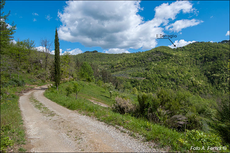
Al bivio siamo andati a sinistra verso Mulino di Faltona che raggiungeremo tra qualche centinaio di metri. Questo punto della strada offre un'ampia vista sulla montagna di fronte e questo è importante per capire l'antica viabilità che qui era presente. Sul crinale del monte scorgiamo un piccolo abitato: è Il Serraglio. La strada su cui stiamo camminando, scesa al torrente, lo attraversava con un ponte medievale a schiena d'asino crollato con l'alluvione del 1966 (oggi sostituito da una passarella). Dal corso d'acqua risaliva il monte fino a Il Serraglio (il percorso è tutt'ora esistente) dove s'inseriva su una strada (oggi CAI 34) che a sinistra conduce a Castel Focognano e ai ruderi del Castello di Civitella sul crinale della montagna che separa i Comuni di Castel Focognano e di Ortignano Raggiolo, fino alla seconda metà del Trecento il confine tra il territorio del Guidi e quello del vescovado aretino. A destra il CAI 34 conduce all'abitato di Ornina (toponimo etrusco) da dove, velocemente, si scende a Sòcana, un sito oggi sede di un'importante pieve romanica, in epoca preromana di un tempio e di una grande ara etrusca.
Dopo queste considerazioni è lecito pensare che stiamo camminando su quell'importante direttrice di probabile origine etrusca (la Via Abversa) che a Socana si dirigeva verso il Valdarno attraversando il Pratomagno e lungo la quale, ci dicono gli Annali Camaldolesi, fu fondata Badia Santa Trinita. Riprendiamo quest'argomento a pagina 19.
At the crossroads we went left towards Mulino di Faltona which we will reach in a few hundred metres. This point of the road offers a broad view of the mountain in front and this is important for understanding the ancient road system that was present here. On the ridge of the mountain we see a small settlement: it is Il Serraglio. The road we are walking on, which descended to the stream, crossed it with a medieval humpback bridge which collapsed in the flood of 1966 (now replaced by a footbridge). From the watercourse it went up the mountain to Il Serraglio (the route still exists) where it joined a road (today CAI 34) which on the left leads to Castel Focognano and the ruins of the Civitella Castle on the ridge of the mountain that separates the municipalities of Castel Focognano and Ortignano Raggiolo, until the second half of the fourteenth century the border between the territory of Guidi and that of the Arezzo bishopric. On the right, CAI 34 leads to the town of Ornina (Etruscan toponym) from where you quickly descend to Sòcana, a site that is now home to an important Romanesque parish church, and in pre-Roman times a temple and a large Etruscan altar.
After these considerations it is reasonable to think that we are walking on that important route of probable Etruscan origin (the Via Abversa) which in Socana headed towards the Valdarno crossing the Pratomagno and along which, the Camaldolese Annals tell us, Badia Santa Trinita was founded . We return to this topic on page 19.


