Trekking tra i borghi del territorio di Faltona
Natura, storia, ampi panorami, corsi d’acqua stupenti e il percorso per Santa Trinita
Italiano
IN VISITA AL TERRITORIO DI FALTONA – TALLA 78
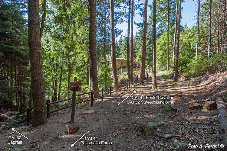
In settecento metri il sentiero CAI 44 ci a fatto scendere da Passo alla Forca (1065 m) a Badia Santa Trinita in Alpe (952 m). Dove il CAI 44 termina la sua discesa (cento metri prima dei ruderi dell'abbazia) a sinistra c'è una fonte. Qui il sentiero si unisce al CAI 32 che è salito da Capraia e insieme raggiungono il Fosso della Badia (duecento metri dopo i ruderi). Pochi metri dopo il corso d'acqua, il CAI 32 (divenuto strada forestale) sale fino a raggiungere il Varco di Anciolina. Il CAI 44 volta a sinistra per raggiungere in due chilometri Fonte Cavallari e in cinque Pontenano.
A Fonte Cavallari possiamo anche lasciare il CAI 44 per scendere al Ponte di Sasso e quindi risalire a Capraia. Vedi questa struttura medievale sul Torrente Capraia e il percorso che ci passa.
In seven hundred meters the CAI path 44 takes us down from Passo alla Forca (1065 m) to Badia Santa Trinita in Alpe (952 m). Where CAI 44 ends its descent (one hundred meters before the ruins of the abbey) on the left there is a spring. Here the path joins the CAI 32 which came up from Capraia and together they reach the Fosso della Badia (two hundred meters after the ruins). A few meters after the watercourse, CAI 32 (which became a forest road) goes up until it reaches the Anciolina pass. CAI 44 turns left to reach Fonte Cavallari in two kilometers and Pontenano in five.
At Fonte Cavallari we can also leave the CAI 44 to go down to Ponte di Sasso and then go back up to Capraia. See this medieval structure on the Capraia stream and the path that passes through it.


