Trekking tra i borghi del territorio di Faltona
Natura, storia, ampi panorami, corsi d’acqua stupenti e il percorso per Santa Trinita
Italiano
IN VISITA AL TERRITORIO DI FALTONA – TALLA 19
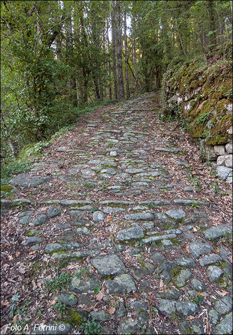
Attraversato il torrente con la passarella, seguiamo il sentiero, a sinistra, che sale leggermente. In pochi metri conduce sullo scoglio dove appoggiava il ponte medievale. Da qui il percorso torna ad essere una strada larga e selciata (nella foto). Non sembra un selciato molto antico, ma questo non vuol dire che non è antico il percorso. La pavimentazione delle strade si deteriorava, così come i moderni asfalti, e veniva rifatta.
Riprendendo quanto scritto a pagina 11 si trattava sicuramente della Via Abversa, direttrice che attraversando il Pratomagno collegava due importanti siti etruschi come Sòcana e Gròpina. Facendo riferimento a tempi molto più recenti rispetto agli etruschi, è opportuno ricordare che fin dall'XI secolo il territorio di Faltona era sotto il dominio del vescovado aretino che aveva il Castello di Focognano come riferimento di potere in questa zona. Il collegamento tra Faltona e Focognano era rappresentato da questa strada. Stessa cosa vale anche dalla seconda metà del XIV secolo quando la Repubblica Fiorentina istituisce a Castel Focognano una podesteria che doveva governare un esteso territorio che comprendeva anche quello di Faltona. Questa situazione politica rimane tale fino al periodo napoleonico quando, nel 1808, fu istituito il Comune di Talla. Poi c'è l'aspetto religioso. Dal medioevo al 1757 il territorio di Faltona e le sue chiese furono subordinate alla Pieve di Socana, qui dovevano essere battezzati i bambini di Faltona. La strada di comunicazione tra questi luoghi era sempre questa.
Having crossed the stream with the footbridge, we follow the path, on the left, which goes up slightly. In a few meters it leads to the rock where the medieval bridge rested. From here the route becomes a wide, stone-paved road again (in the photo). It doesn't look like a very ancient pavement, but this doesn't mean that the path isn't ancient. The pavement of the streets deteriorated, as did modern asphalt, and was resurfaced.
Going back to what was written on page 11, it was certainly the Via Abversa, a route that crossed the Pratomagno and connected two important Etruscan sites such as Sòcana and Gròpina. Referring to much more recent times than the Etruscans, it is worth remembering that since the 11th century the territory of Faltona was under the dominion of the Arezzo bishopric which had the Focognano Castle as a reference point of power in this area. The connection between Faltona and Focognano was represented by this road. The same thing also applies from the second half of the 14th century when the Florentine Republic established a podesta office in Castel Focognano which was to govern an extensive territory which also included that of Faltona. This political situation remained so until the Napoleonic period when, in 1808, the Municipality of Talla was established. Then there is the religious aspect. From the Middle Ages to 1757 the territory of Faltona and its churches were subordinated to the Parish Church of Socana, where the children of Faltona had to be baptized. The communication road between these places was always this.


