On the path of iron and transhumance
itinerary on the southern slopes of Pratomagno from Pontenano to the Crocina Pass
Texts and photos by Alessandro Ferrini ©
71 images in sequence to learn about this itinerary in Pratomagno. Click to start the virtual excursion
From Pontenano to the Crocina Pass on the iron and transhumance route
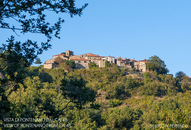
 The itinerary that we are about to describe winds along the southern slopes of Pratomagno and can be considered of medium difficulty. In fact, it has a length of approximately 12 kilometers and a total altimetric variation of 1100 metres. The starting and finishing point of the route is Pontenano, at almost eight hundred meters above sea level. This mountain village in the municipality of Talla is located 7.5 kilometers after the capital for those coming from Casentino. For those who want to get there from Arezzo or Valdarno, the shortest route is to go up from the Crocina Pass. On this route we will be accompanied by a beautiful natural environment and panoramic views. At the same time we will find ourselves "walking through history", from the medieval one to a relatively recent one when, still at the beginning of the 1950s, the last shepherds left here for the Maremma.
We know little about the ancient history of Pontenano. It probably began in the 7th century with a Lombard settlement. These people liked the area because from up here they had a visual control over the territory towards Arezzo. Again due to its dominant position, it is documented that already in the 11th century the place was disputed by powerful families from Valdarno. Another reason that made this area important was that an important route passing through it connected Badia Santa Trinita (five kilometers from here) with Arezzo. It was precisely the bishopric of this city that brought everyone together when it definitively made this area its own in the 12th century. It is the moment that the castle was built, which is remembered as the most powerful in Pratomagno. A chronicle from 1385, the period in which Pontenano came under Florentine rule, reports that as many as two hundred armed men were present there. In 1426 the Republic of Florence decreed the destruction of the castle to punish its inhabitants guilty of having hosted the men of Niccolò Piccinino, a mercenary captain in the service of the Visconti of Milan, the previous year.
Today Pontenano can show little, but not nothing, of its glorious past. Where the castle walls were facing Arezzo there is still a door. Other evidence is a large bell still in use and dated 1352. This is what can be seen during a quick visit to the town. There is, however, much more, something very fascinating that shows us the itinerary that we begin to describe.
Before starting the actual walk, let's head onto the slightly uphill asphalt road that leads towards Pratomagno (we can also go by car). After 450 metres, at the end of the guard rail on the outside of a wide right bend, a few meters below the road there are the remains of a medieval tower, locally called "Torrione". What would its function have been? We'll find out soon. Having seen this architectural testimony, at least fourteenth century, but probably earlier, we return to Pontenano from where we begin the walk taking the narrow road that in about three hundred meters leads to Cerreto, a small cluster of houses. At a bend to the left we take a small road, on the
  right, which goes up into the woods. From here we will have to do about six hundred meters of easy ups and downs, then we will go back. After 250 meters of walking we begin to find walls to the right of the road. They are not the usual dry stone walls that support the terraces of the fields. They are built with huge stones many of which are well work. We entered an area called "Castellaccio" and there are many of those dry stone walls with large squared stones, even under the road (which is difficult to see). A little higher up are the remains of the tower seen previously. By putting together these fascinating stone artefacts with the toponym Castellaccio, it is easy to understand that we are in a place that was fortified. How come? The castle was located where the town of Pontenano is today. We continue our journey on the same path. This, at the bottom of a short descent, on a bend to the left, is crossed by a small stream: it is the Fosso della Villa. Next to this there is a wall that seems to close off something that was certainly not a field. This space was probably a millpond, but what could this small dam have been used for? A document from the 15th century gives us an explanation where it speaks of a "large iron factory" present in Pontenano as early as the 14th century, but perhaps even earlier. In this ironworks, which was also a foundry, weapons were produced, first for Arezzo, then for Florence. Here, then, is where we arrived with this short walk from Pontenano. This is confirmed by the testimonies of hunters who, just below the road, have repeatedly found ferrous material of an amorphous shape, probably melting residues, "sbavature of iron", they call them. Beyond the Fosso della Villa the road begins to climb. We continue along it for another two hundred meters. We will arrive at a panoramic point from which we have a beautiful view of the Alpe di Catenaia. Behind this we distinguish an imposing peak, it is Monte Nerone. We have visually arrived in the Marche.
Let's go back, but not to Pontenano. At the crossroads where we started to climb, we turn right and in about a hundred meters we reach Cerreto. Almost at the end of this small town, on a building to the left of the road there are two ugly faces chiseled into the stone. They are apotropaic figures, they served to keep evil away from this place. In front of this house a path begins to descend which leads to a road below right in front of a very strangely shaped building. It is the so-called "Fonte Vecchia di Pontenano".
  A local tradition says that the source of the castle was there. Here we go right, downhill. This road, today corresponding to CAI 48, is wide and in many sections we find clear paving made with carefully arranged stones. The walls along the route are also well made. All this is evidence of an important path. In fact, until the advent of motorized vehicles, and the consequent creation of roads suitable for them, it was the road that connected Pontenano with Arezzo and Valdarno. In three kilometers it will lead us to the Crocina Pass. This path is very ancient. It was part of the aforementioned route that connected Badia Santa Trinita, the Castle of Pontenano and Arezzo. Its importance is also due to its use for the transport of precious goods such as the weapons produced in the "big iron factory". Furthermore, for centuries it was the most important transhumance road for the shepherds of Pontenano and other surrounding areas, a practice that ended in the early 1950s.
From Fonte Vecchia di Pontenano, after about six hundred meters on the CAI 48, we reach a bend to the left (ten meters beyond this there is a crossroads) where the road crosses with the Fosso della Villa, already encountered at the ancient ironworks. Let's stop for a moment to look down on the wall that supports the road at this point. It is an extraordinary work of dry masonry about three meters high. The lower part is made up of slab-shaped stones well arranged horizontally. At the top, however, the stones are fitted together vertically, a so-called "thorn" arrangement. The wall is arched because it follows the curve above. A work that does not show the slightest sign of lime, yet of incredible robustness. Not even a stone has moved although several centuries have certainly passed since its creation. It is difficult to say how many, but, as already mentioned, let's keep in mind that already in the 14th century this road had considerable importance.
Ten meters beyond the Fosso della Villa we find a crossroads. We follow the CAI 48 which goes right uphill for a few meters, then goes down again. From the path on the left, downhill, we can possibly return so as not to take the same road. We will see how later.
 From the Fosso della Villa, in about 1.3 kilometres, the CAI 48 takes us down to the Fosso di Querceto (590 metres) which we can cross with a small bridge. A true gem of Romanesque architecture. These works date back to the 13th or 14th century. To be built, an economic motivation was needed which was generally the presence of a mill. In this case it was certainly the ironworks with its precious product that justified the construction of the bridge. From the Fosso di Querceto, the CAI 48 takes us up to the 672 meters of the Crocina Pass in one kilometre. In this last stretch the road no longer has the pavement seen previously, probably due to various renovations carried out to allow the passage of forestry vehicles.
At the Crocina Pass the CAI 48 joins the CAI 00 on the Pratomagno ridge. We enter the asphalt road (SP59) and begin to descend towards Valdarno. After eight hundred meters we reach a crossroads which marks the beginning, on the right, of the Pratomagno panoramic road. We follow this direction, but after only thirty meters we leave the asphalt road to take a forest track, again on the right. Until the 1960s this road was paved, then the passage of forestry vehicles blew away the stones in the pavement. We are following the road that the transhumant shepherds of Pontenano followed. After about four hundred meters we will join the CAI 41, a very short distance from the Pratomagno panoramic road (we are at 690 meters above sea level). This last route arrives here from the CAI 00 on the ridge and after having descended the asphalt road for two hundred metres, it exits it, to the right, to reach San Giustino Valdarno in around three kilometres. The place where we joined the CAI 41 is known as Villa Cognola, from the name of a large building (two hundred meters higher, to the left of the asphalt road) where a fire base was built. At the same time it is worth remembering that some still call this area "customs", a particularly significant toponym when talking about transhumance.
We begin to travel along the CAI 41 towards the mountain ridge. With this route we enter the most wooded part of the itinerary, there will be fir and beech trees to accompany us on this journey, but we will also find turkey oaks and some chestnut trees. In about 1.5 kilometers we reach the intersection with CAI 00 (790 metres) which
  we must take on the right, downhill. From here the most present plants will be pines and firs, but we will also cross some clearings which will offer us beautiful panoramic views. We will see in front of us the wind turbines located just above the Crocina Pass where we are heading. From the end of CAI 41, in about a kilometer we arrive at another intersection. We must follow the CAI 00, on the right. On the left, in two hundred meters, we will arrive in Feraglia, a small group of houses. From here the route became a forest road. After a short while we will pass a few meters from a memorial stone which reminds us of the killing of the partisan Giuseppe Manni in this place. Another kilometer and we are back at the Crocina Pass where we return to the CAI 48 to return to Pontenano. After about eight hundred meters of descent we find a crossroads. CAI 48, where we came from, is the left road, but we can also take the right route. This is the possible variant we mentioned. We will extend the itinerary by approximately three hundred meters and the total altimetric variation will increase by seventy meters. We will not pass over the Fosso di Querceto bridge, but we will avoid traveling 1.5 kilometers on a route taken shortly before. We will return to CAI 48 at the Fosso della Villa, where we had observed the dry stone wall under the road. Once we arrive at Fonte Vecchia di Pontenano, we go right. After two hundred meters, we find, on the left, a path with steps that takes us back into the town, to the point where we had seen the door of the ancient castle.


