Il Rifugio di Buite, la Pozza Nera, la croce
un itinerario nel cuore del Pratomagno, il massiccio tra Casentino e Valdarno
Italiano
ITINERARIO BUITE – POZZA NERA – CROCE PRATOMAGNO 56
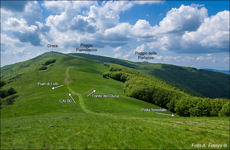
Alla fine del bosco presente sul colle abbiamo davanti a noi l’immagine più bella che può offrire il crinale del Pratomagno: un grande prato fino a Poggio delle Portacce. Luogo, questo, dove il nostro itinerario ci conduce in circa tre chilometri da qui e dove lasceremo il crinale per scendere, in cinquecento metri, al punto di partenza dell’escursione: Le Tre Fonti. La grande croce sembra fare da sentinella a questo magnifico ambiente. In primo piano abbiamo quello che per secoli è stato uno dei pascoli più ambiti del Pratomagno: Prato Romito. Non a caso qui confluiscono vari percorsi. Vi arriva una pista forestale, quella di cui abbiamo visto l’inizio a pagina 33, dove abbiamo imboccato la strada opposta per raggiungere il CAI 30. Parte da qui un sentiero per la Fonte del Duca, lo abbiamo visto alle pagine 15 e 16. A sinistra scende un percorso sul versante valdarnese della montagna che in poco più di un chilometro conduce a Pian di Lelli. Oggi una bella area attrezzata tra i faggi lungo la strada panoramica del Pratomagno, a tre chilometri dal tunnel. At the end of the wood on the hill we have before us the most beautiful image that the Pratomagno ridge can offer: a large meadow up to Poggio delle Portacce. This is the place where our itinerary takes us about three kilometers from here and where we will leave the ridge to descend, in five hundred metres, to the starting point of the excursion: Le Tre Fonti. The large cross seems to act as a sentry to this magnificent environment. In the foreground we have what for centuries has been one of the most sought-after pastures in Pratomagno: Prato Romito. It is no coincidence that various paths converge here. A forest track arrives there, the one whose beginning we saw on page 33, where we took the opposite road to reach the CAI 30. A path starts from here for the Fonte del Duca, we saw it on pages 15 and 16. To the left a path descends on the Valdarno side of the mountain which in just over a kilometer leads to Pian di Lelli. Today a beautiful equipped area among the beech trees along the Pratomagno panoramic road, three kilometers from the tunnel.


