FROM PASSO DELLA CALLA TO POGGIO SCALI
an itinerary in the National Park of the Casentino Forest
Texts and photos by Alessandro Ferrini ©
54 images in sequence to learn about this itinerary in the Casentino Forests. Click to start the virtual excursion
Trekking in the National Park: Giogana from Passo della Calla to Poggio Scali
 Since ancient times, the Passo della Calla road has been a very important communication route. The Etruscans already used it, but the Romans even more in their military and commercial movements between Arezzo and Ravenna.
The name Calla is quite common. It means a place where one could count, that is, a customs point. Compared to the Roman period we have moved a thousand years later, in medieval times, the thirteenth and fourteenth centuries. What did it count? Generally the sheep, that is, those precious animals that produced the white gold of that period, the wool. The transhumance that the Casentino shepherds practiced towards the Maremma is known, this movement involved a very large number of flocks. Although with much lower numbers, there was also a transhumance towards Romagna which interested the breeders of the highest part of the Casentino. This was the most used road and right on the Apennine ridge the sheep that were moved were counted because they were subject to taxation.
Passo della Calla is about fifteen kilometers from Stia, the first town bathed by the Arno which has its source on Monte Falterona, not far from the pass. Going down to the land of Romagna, after a few kilometers we meet Campigna. This town is known for its forests which for several centuries were the property of the Opera del Duomo in Florence. From these woods and from those of the nearby Foresta della Lama (again by the same owner), large trunks were obtained for the construction of beams for important Florentine buildings, the most famous being the Duomo. Campigna was the vacation spot and hunting reserve of the Grand Duke of Tuscany Pietro Leopoldo. Continuing to descend the Romagna slopes of the Apennines, we meet Corniolo. From this inhabited area begins a road that leads us to visit well-known places in the National Park of the Casentinesi Forests, Monte Falterona and Campigna: the Botanical Garden of Valbonella, Castel dell’Alpe, but above all the Grotta Urlante and the Premilcuore Waterfall. Resuming the descent on the Calla road, a few kilometers before Santa Sofia, a crossroads on the right leads to the Ridracoli Dam, a splendid reservoir in the mountains that we will be able to see from above near Poggio Scali, along the path we describe in following.
At Passo della Calla, the asphalted road that crosses the Apennines crosses the ridge GEA 00. In a north-western direction this route reaches the highest peaks of the National Park: Monte Falco, 1658 m, and Monte Falterona, 1654 m. We will take it in the opposite direction. In about five kilometers it will take us from the 1296 meters of Passo della Calla to the 1520 meters of Poggio Scali.
 The route immediately offers us a climb accompanied by majestic beech trees, not very demanding, but constant. In almost two kilometers it takes us to Il Poggione, a mountain of 1424 meters. The GEA 00 does not pass on its summit but on the Tuscan side. From here the road continues in a pleasant ups and downs, it looks like a narrow channel in the beech forest. Even if we are on a ridge and at high altitude, the views are practically nil due to the dense vegetation. A canal from which it is forbidden to leave because on the left we have the Sasso Fratino Integral Nature Reserve, on the right the La Pietra Nature Reserve. This last protected area will accompany a large part of our excursion as it is delimited at the top by the ridge path, then by CAI 78 which we will use to descend to Aia di Dorino. From here we will use the MBT 8 track to return to Passo alla Calla. This wide path marks the lower boundary of the La Pietra Nature Reserve. Less than a kilometer from Poggio Scali, the GEA 00 takes us through spectacular rocks. Then finally it offers us a couple of points from which we can enjoy a beautiful view to the east. From the second we also see a branch of the Ridracoli Dam.
Once at the foot of Poggio Scali, the GEA 00 keeps to the right going up slightly.
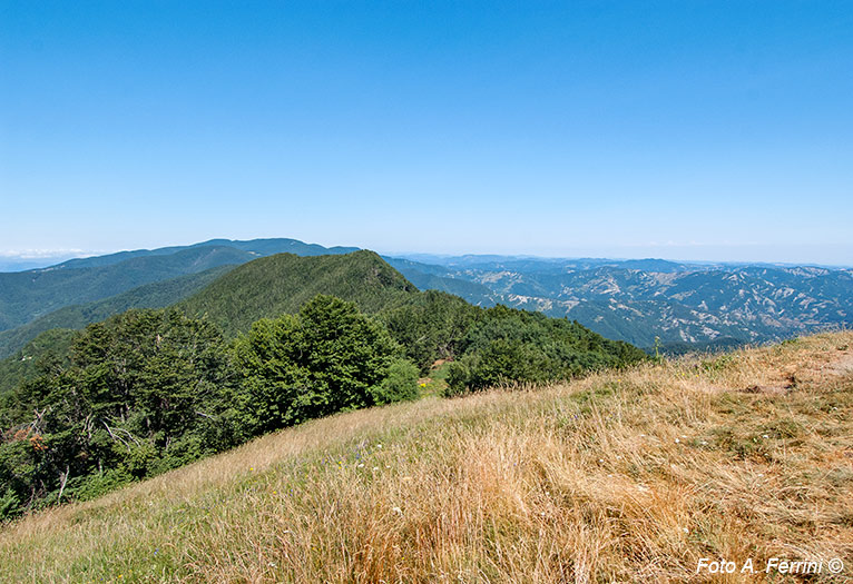
 On the left, however, a steep but short path allows us to climb the mountain, 1520 meters. A few meters before reaching the top, let's turn to our right: an opening between the trees shows us, on the horizon, a part of the Pratomagno massif, the mountain that separates the Casentino from the Valdarno. On the summit of Poggio Scali we can rest on a small lawn while enjoying a sandwich, but not before having observed the view. On the direction from which we arrived we will see the Apennine ridge with Monte Falterona on the horizon. On the opposite side, even if the view is partly blocked by plants, the Apennine chain accompanies our gaze towards a mountain with a square top. It is La Verna, a place very dear to San Francesco.
We continue our journey descending Poggio Scali with a path to the right of the one we arrived from. In less than a hundred meters it takes us back to GEA 00 which we take to the left, towards the south. In about a kilometer we reach Passo Porcareccio where on the right begins the CAI 78 path which after 1.4 kilometers of descent, at times quite steep, overlaps the MBT 8 which comes, on the left, from Capanna La Maremmana. In seven hundred meters of gentle descent, the two paths descend to Aia di Dorino, 1214 meters. Here the CAI 78 continues straight, the MBT 8 makes a sharp bend to the right, we will continue on this wide downhill track. After two hundred meters, on the right, there is a source. Good opportunity to fill our bottle with fresh water. After 1.3 kilometers we will cross Il Fossatone, a beautiful stream that flows between a lush beech forest. We are at 1115 meters above sea level, the lowest point of the itinerary. From here the path begins a steady but not demanding climb.
  There are about five kilometers to go back to our starting point and we will have to climb only 180 meters. On our right we have the splendid La Pietra Integral Reserve.
Near the Borro delle Fogne, the comfortable and wide MBT 8 becomes a narrow path for about two hundred meters. There are a couple of points that need to be addressed carefully, then go back to widening. Approaching the road to the Passo alla Calla the wood becomes mixed and together with the beech trees we will see majestic fir trees.
Once we reach the asphalted road we begin to climb it. After about three hundred meters, inside a bend to the right, we find the Aia delle Guardie, now transformed into an area equipped with comfortable tables. In this place we can have a lunch or a snack accompanied by extraordinary water, both in terms of taste and quality. In fact, continuing to climb a hundred meters beyond the bend, on the left of the road we find the well-known Fonte di Calcedonia (1190 m). This water has undisputed purifying properties for our body. A few tens of meters before the source, CAI 80 begins on the left of the paved road, a wide path immersed in a lush forest that will quickly bring us back to the starting point of the excursion. After turning right at the only fork we will meet, just before the Passo della Calla we will find other areas equipped with benches and tables.


