Dal piccolo borgo di Capraia a Santa Trinita
Il sentiero da Capraia a Badia Santa Trinita e possibile ritorno su due percorsi diversi
Italiano
LUOGHI E PERCORSI NEI PRESSI DI BADIA SANTA TRINITA 1
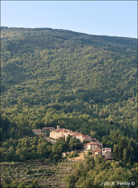
Vista di Capraia dalla zona di Pieve Pontenano. L'immagine mostra in modo evidente come il piccolo borgo del Comune di Talla, a 638 metri di quota, sia posto sulle ripidi e rocciose pendici di un monte. Un "luogo da capre", come dice chiaramente il toponimo. Questi animali, infatti, erano posseduti da tutte le famiglie di Capraia. A differenza delle pecore che ve ne erano pochissime, giusto per il fabbisogno personale: un po' di latte per il formaggio, un po' di lana per qualche maglia. Non c'erano terreni adatti dove questi animali potessero pascolare.
Le pendici irte e sassose del monte dove Capraia si trova "abbarbicata" sono rivolte a sud-ovest. Una zona calda e arida, quindi, protetta dal freddo vento di tramontana. È per questo che molti di quei piccoli fazzoletti di terra un tempo utilizzati per la coltivazione di prodotti indispensabili nella povera economia delle famiglie sono stati trasformati in oliveti. Non certo per grosse produzioni di olio, giusto per il fabbisogno di una famiglia e per non lasciare ai rovi quei terreni che per secoli sono stati indispensabili per la sopravvivenza delle persone. Vediamo qualche oliveto in basso nella foto.
View of Capraia from the Pieve Pontenano area. The image clearly shows how the small village of the Municipality of Talla, at 638 meters above sea level, is located on the steep and rocky slopes of a mountain. A "place for goats", as the toponym clearly says. These animals, in fact, were owned by all the families of Capraia. Unlike the sheep, there were very few of them, just for personal needs: a little milk for the cheese, a little wool for a few shirts. There was no suitable land where these animals could graze.
The steep and stony slopes of the mountain where Capraia is "perched" face south-west. A hot and arid area, therefore, protected from the cold north wind. This is why many of those small plots of land once used for the cultivation of indispensable products in the poor family economy have been transformed into olive groves. Certainly not for large productions of oil, just for the needs of a family and not to leave to brambles those lands that for centuries have been indispensable for the survival of people. We see some olive groves at the bottom of the photo.


