Cammino Bizantino nel Comune di Talla
Passeggiata tra Casentino e Valdarno per scoprire testimonianze di questa civiltà
Italiano
PASSEGGIATA IN UN TERRITORIO BIZANTINO 17
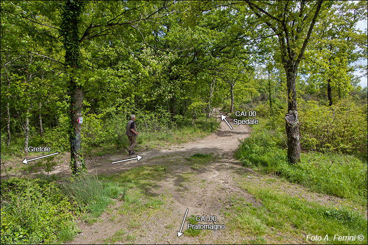
La pista forestale in 1,9 chilometri dalla SP59 ci ha condotto al percorso CAI 00 del Pratomagno. Lo imbocchiamo verso sinistra, in direzione Spedale, Torre di Belfiore. Tra duecentocinquanta metri giungeremo al bivio con il CAI 53 che scende a Castiglion Fibocchi e tra seicento sul Poggio della Basèlica.
In direzione opposta, il CAI 00 un due chilometri raggiunge il Passo della Crocina da dove inizia la sua salita verso le cime più alte del Pratomagno. A questo passo, dal CAI 00 parte il CAI 48 che in circa tre chilometri raggiunge Pontenano dopo esser sceso al Fosso di Querceto che attraversa con un piccolo ponte databile XIII- XIV secolo. Un percorso di altissima importanza: dal medioevo all'avvento dei mezzi motorizzati ha rappresentato il collegamento di Pontenano e Badia Santa Trinita con Arezzo. Una strada del ferro e della transumanza. Capiamo perché visitando questa sezione web.
The forest track 1.9 kilometers from the SP59 led us to the CAI 00 route of Pratomagno. We take it to the left, towards Spedale, Torre di Belfiore. In two hundred and fifty meters we will reach the crossroads with the CAI 53 which goes down to Castiglion Fibocchi and in six hundred on Poggio della Basèlica.
In the opposite direction, the CAI 00 reaches the Crocina Pass after two kilometers from where it begins its climb towards the highest peaks of Pratomagno. At this pass, CAI 48 starts from CAI 00 and reaches Pontenano in about three kilometers after descending to the Fosso di Querceto which it crosses with a small bridge dating back to the 13th-14th century. A route of the highest importance: from the Middle Ages to the advent of motorized vehicles it represented the connection between Pontenano and Badia Santa Trinita with Arezzo. A road of iron and transhumance. We understand why by visiting this web section.


