Cammino Bizantino nel Comune di Talla
Passeggiata tra Casentino e Valdarno per scoprire testimonianze di questa civiltà
Italiano
PASSEGGIATA IN UN TERRITORIO BIZANTINO 25
In circa quattrocento metri di salita siamo giunti sulla cima di Poggio della Basèlica. Questo toponimo è molto interessante: risale con ogni probabilità al periodo in cui questa parte d'Italia era contesa tra Longobardi e Bizantini (VII-VIII secolo). Tale termine lo troviamo spesso lungo la striscia di territorio che divideva queste due civiltà. Il toponimo è attribuibile ai Bizantini, insieme ad altre tracce non lontane da qui: santi di devozione orientale come San Mamante (oggi Santa Mama), Sant'Eleuterio (oggi Salutio), Sant'Apollinare a cui sono dedicate la chiesa di Campovecchio, che ci accingiamo a raggiungere, e un'altra in località Il Santo, nel Comune di Capolona.
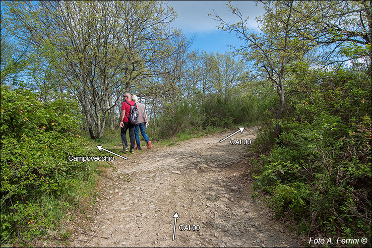
Su Poggio della Baselica, per continuare il nostro cammino verso Campovecchio, dobbiamo imboccare la pista forestale a sinistra che ci mostra la foto. Prima, però, consigliamo di continuare per altri venti metri sul CAI 00 per poi voltare su un'altra pista forestale a destra. Dopo meno di cento metri avremo alla nostra sinistra uno splendido panorama su Arezzo e la Vadichiana.
After about four hundred meters of climbing we reached the top of Poggio della Basèlica. This toponym is very interesting: it most likely dates back to the period in which this part of Italy was disputed between the Lombards and the Byzantines (7th-8th century). This term is often found along the strip of territory that divided these two civilizations. The toponym can be attributed to the Byzantines, together with other traces not far from here: saints of oriental devotion such as San Mamante (today Santa Mama), Sant'Eleuterio (today Salutio), Sant'Apollinare to whom the church of Campovecchio is dedicated, which we are about to reach, and another in the Il Santo area, in the Municipality of Capolona.
On Poggio della Baselica, to continue our journey towards Campovecchio, we must take the forest track on the left that the photo shows us. First, however, we recommend continuing for another twenty meters on CAI 00 and then turning onto another forest track on the right. After less than a hundred meters we will have a splendid view of Arezzo and the Vadichiana on our left.


