Da un antico castello all’erboso crinale
itinerario sul Pratomagno valdarnese: da Trappola alla Bottigliana e alla Pozza Nera
Italiano
ITINERARIO TRAPPOLA – CIMA BOTTIGLIANA – POZZA NERA 29
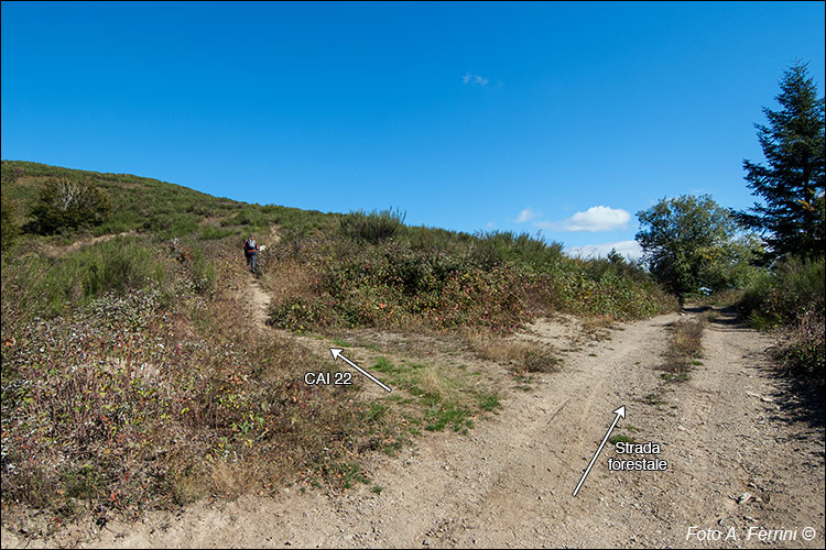
Al termine del bosco il CAI 22, che si sovrappone alla pista forestale, volta a destra, ma dopo qualche decina di metri la lascia per voltare a sinistra, salendo, e tornare un sentiero. Poco prima di questo incrocio, guardando a destra, vediamo una scaletta che serviva ad attraversare un recinto. Siamo all’inizio del bosco, oltre la scaletta in una ventina di metri possiamo raggiungere dall’alto la Grotta del Pastore. Sicuramente in un passato non troppo lontano i prati arrivavano fino a questo grande masso, poi, con l’abbandono dei pascoli, il bosco è avanzato indisturbato. A questo incrocio l’itinerario ci offre tre varianti. Per il percorso più breve (11 chilometri) seguiamo il CAI 22 che dopo circa quattrocento metri va ad immettersi sul CAI 00 di crinale alla fine della Bottigliana, verso nord. Lì volteremo a sinistra lasciandoci la cima alle spalle. Possiamo, invece, seguire la pista forestale che in cinquecento metri ci conduce sempre su CAI 00, ma sulla parte discendente verso sud della Bottigliana. Qui volteremo a sinistra. Allungheremo di neppure un chilometro il percorso e aumenteremo di cinquanta metri il dislivello altimetrico, ma ci godremo la bellezza della Cima Bottigliana e dei suoi panorami. Con le prossime pagine, invece, descriviamo il percorso più lungo (14 chilometri). Ora continuiamo sul CAI 22, all’arrivo sul CAI 00 di crinale faremo una deviazione che mostriamo alle pagine 32 e 33. At the end of the forest, CAI 22, which overlaps the forest path, turns right, but after a few dozen meters it leaves it to turn left, going up, and returning to a path. Just before this intersection, looking to the right, we see a ladder that was used to cross a fence. We are at the beginning of the forest, beyond the ladder in about twenty meters we can reach the Shepherd's Cave from above. Certainly in a not too distant past the meadows reached up to this large boulder, then, with the abandonment of the pastures, the forest advanced undisturbed. At this crossroads the itinerary offers us three variations. For the shortest route (11 kilometres) we follow the CAI 22 which after about four hundred meters joins the CAI 00 on the ridge at the end of Bottigliana, towards the north. There we will turn left leaving the summit behind us. We can, however, follow the forest track which in five hundred meters still leads us to CAI 00, but on the descending part towards the south of the Bottigliana. Here we will turn left. We will extend the route by not even a kilometer and increase the altitude difference by fifty meters, but we will enjoy the beauty of Cima Bottigliana and its views. In the next pages, however, we describe the longest route (14 kilometres). Now we continue on CAI 22, upon arrival on CAI 00 on the ridge we will make a detour which we show on pages 32 and 33.


